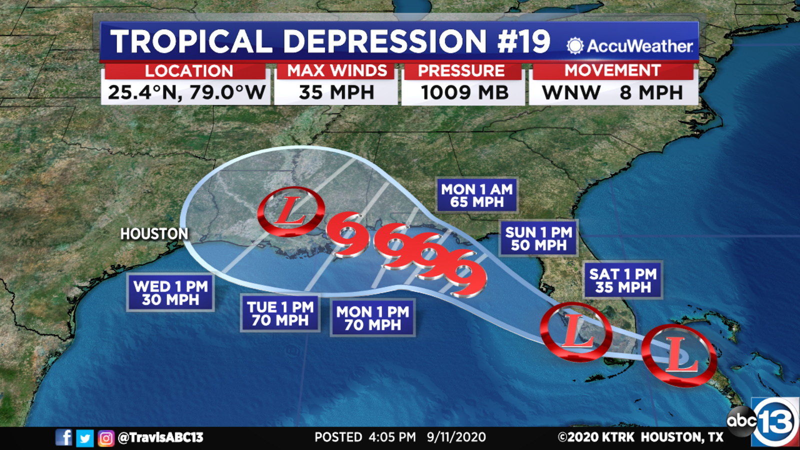
The storm's projected track sends it drifting westward over south Florida on Saturday and then out into the open Gulf waters later that day.
According to the National Hurricane Center's forecast, the depression, which holds maximum sustained winds near 35 mph, could also become a tropical storm before moving across south Florida overnight.
Nevertheless, TD No.19 is expected to become a tropical storm by Sunday and steadily intensify to near hurricane strength by Monday.
Tropical storm, storm surge, and hurricane watches could be issued from Louisiana to the Florida Panhandle as early as tonight, if not Saturday.
At this time it is unlikely Texas will be impacted by Tropical Depression 19, but we cannot completely rule it out just yet.
There is also a tropical disturbance over the central Gulf, but it only has a low (30%) chance of developing as it tracks closer to the Texas coastline this weekend. It will likely bring us scattered tropical downpours Sunday afternoon and Monday as it curves toward Mexico.
We aren't overly concerned about either one of these for now, but we will be keeping a watchful eye on them as they move generally westward in the days ahead.
Meanwhile, Paulette and Rene continue to spin safely away from land over the Atlantic. Neither of these storms will threaten the Gulf Coast.
A large tropical wave just departed Africa, and it has a high (90%) chance for development over the next 5 days. Because this one is tracking farther south than the waves that became Paulette and Rene, it should generally track westward toward the Caribbean, and we cannot rule out eventual impacts to the Gulf of Mexico at this time. If it were to ever enter the Gulf, impacts would be sometime between September 20th to 25th, so it's nothing to worry about at this time. You'll just want to stay aware of what it's doing just in case.
Sally, Teddy, Vicky, and Wilfred are the remaining names on the 2020 Atlantic hurricane list.
We have already tied the record for the most named storms through the end of September, and we still have three weeks to go. If we run out of names, we will move on to using the letters of the Greek alphabet. The only time that's happened was in the record-breaking 2005 hurricane season.
We are now in the weeks of peak hurricane activity, so make sure you stay prepared and have your hurricane preparedness plan in place.
RADAR MAPS:
Southeast Texas
Houston
Harris County
Galveston County
Montgomery/Walker/San Jacinto/Polk/Grimes Counties
Fort Bend/Wharton/Colorado Counties
Brazoria/Matagorda Counties
SHARE YOUR WEATHER PHOTOS: Send us pics and video of weather in your area to news@abc13.com and at #ABC13Eyewitness on social media.
During hurricane season, remain prepared and make sure you download our ABC13 Houston app!
WTNT34 KNHC 112056
TCPAT4
BULLETIN
Tropical Depression Nineteen Advisory Number 1
NWS National Hurricane Center Miami FL AL192020
500 PM EDT Fri Sep 11 2020
...TROPICAL STORM WATCH ISSUED FOR SOUTHEASTERN FLORIDA AS NEW
TROPICAL DEPRESSION FORMS...
SUMMARY OF 500 PM EDT...2100 UTC...INFORMATION
----------------------------------------------
LOCATION...25.4N 79.0W
ABOUT 80 MI...130 KM ESE OF MIAMI FLORIDA
MAXIMUM SUSTAINED WINDS...35 MPH...55 KM/H
PRESENT MOVEMENT...WNW OR 285 DEGREES AT 8 MPH...13 KM/H
MINIMUM CENTRAL PRESSURE...1009 MB...29.80 INCHES
WATCHES AND WARNINGS
--------------------
CHANGES WITH THIS ADVISORY:
A Tropical Storm Watch has been issued for the coast of
southeastern Florida from south of Jupiter Inlet to north of Ocean
Reef.
SUMMARY OF WATCHES AND WARNINGS IN EFFECT:
A Tropical Storm Watch is in effect for...
* South of Jupiter Inlet to north of Ocean Reef
A Tropical Storm Watch means that tropical storm conditions are
possible within the watch area, in this case within the next
6 to 12 hours.
Interests along the northern Gulf Coast should also be monitoring
the progress of this system. Tropical storm or hurricane watches
could be issued for a portion of that area tonight or on Saturday.
For storm information specific to your area, including possible
inland watches and warnings, please monitor products issued by your
local National Weather Service forecast office.
DISCUSSION AND OUTLOOK
----------------------
At 500 PM EDT (2100 UTC), the center of Tropical Depression Nineteen
was located near latitude 25.4 North, longitude 79.0 West. The
depression is moving toward the west-northwest near 8 mph (13
km/h). On the forecast track, the depression is forecast to move
inland over south Florida early on Saturday, move into the
southeastern Gulf of Mexico late Saturday, and then move
northwestward over the north-central Gulf of Mexico on Monday.
Maximum sustained winds are near 35 mph (55 km/h) with higher gusts.
The depression could become a tropical storm before moving across
south Florida overnight. Otherwise it is expected to become a
tropical storm on Sunday and gradually intensify through Monday.
The estimated minimum central pressure is 1009 mb (29.80 inches).
HAZARDS AFFECTING LAND
----------------------
WIND: Tropical storm conditions are possible within the watch
area within the next 6 to 12 hours.
RAINFALL: Tropical Depression Nineteen is expected to produce total
rainfall amounts of 1 to 3 inches with isolated maximum amounts of 5
inches across central and southern Florida, including the Florida
Keys. This rainfall could produce isolated flash flooding and
prolong ongoing minor flooding on rivers in the Tampa Bay area.
NEXT ADVISORY
-------------
Next intermediate advisory at 800 PM EDT.
Next complete advisory at 1100 PM EDT.
Copyright © 2020 KTRK-TV. All Rights Reserved.
"impact" - Google News
September 12, 2020 at 04:31AM
https://ift.tt/3hmNpCE
Tropical Depression No. 19 forms and could impact Gulf Coast as a hurricane - KTRK-TV
"impact" - Google News
https://ift.tt/2RIFll8
https://ift.tt/3fk35XJ
Bagikan Berita Ini


0 Response to "Tropical Depression No. 19 forms and could impact Gulf Coast as a hurricane - KTRK-TV"
Post a Comment