

Hurricane Ida continues to intensify over the Gulf of Mexico and is expected to reach the coast of Louisiana at Category 4 strength as early as Sunday afternoon, on the 16th anniversary of Hurricane Katrina making landfall. The National Hurricane Center warns that the “extremely dangerous” storm may lead to “potentially catastrophic” wind damage when it comes ashore, as well as a life-threatening storm surge, and flooding heavy rainfall. Mandatory evacuation orders are in place for all New Orleans residents outside the levee system and numerous other coastal areas under threat in Louisiana and Mississippi. Below are updates about Ida’s projected path and potential impact.
The current forecast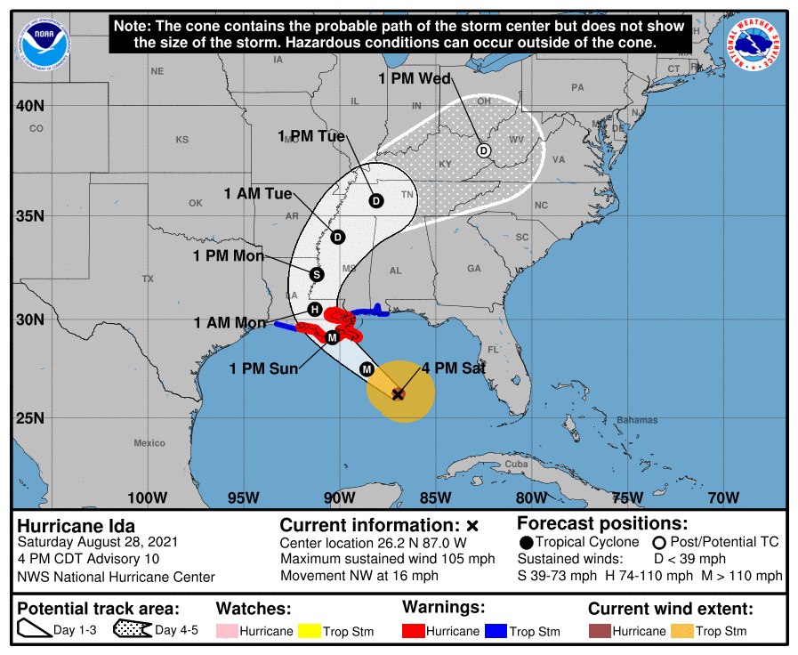
As of late Saturday, Ida had reached Category 2 strength and was continuing to intensify as it traveled northwest over the Gulf of Mexico, a few hundred miles southeast of the mouth of the Mississippi River. A hurricane warning is in effect from the state’s central coast east to the Mississippi border. Storm surge warnings extend east to the Alabama-Florida border.
Ida is currently projected to make landfall as a major hurricane along the central Louisiana coast on Sunday afternoon or evening, likely to the southwest of New Orleans. Ida is forecast, with high confidence, to come ashore as a Category 4 hurricane with 130-mph winds, and may produce a life threatening 10-15 foot storm surge in some areas:
Ida is also expected to produce heavy rainfall, particularly as it slows over land, with the threat of flash and urban flooding across much of Louisiana and Mississippi. Some areas of coastal Louisiana may receive 15 to 20 inches of rainfall or more.
Tropical storm-force winds from Ida are expected to begin affecting coastal Louisiana on Sunday morning.
On Saturday night, the National Weather Service in New Orleans sent out a very dire public information statement for any residents who hadn’t yet left mandatory evacuation zones along the coast:
The threat to infrastructure and industrial sitesPlease understand this, there is the possibility that conditions could be unlivable along the coast for some time and areas around New Orleans and Baton Rouge could be without power for weeks. We have all seen the destruction and pain caused by Harvey, Michael, and Laura. Anticipate devastation on this level and if it doesn’t happen then we should all count our blessings. Please again, if you have the means to leave, and you are 1 in a mandatory or voluntary evacuation zone, LEAVE; 2 are in a very flood prone area, LEAVE, 3 are uncomfortable and have trees around your house, LEAVE. Do not play around and say “I’ve been through Andrew/Camille/Katrina/Betsy” all storms are different.
Ida poses a significant threat to several important industries, as Jeff Masters and Bob Henson explain at Yale Climate Connections:
Ida is predicted to track over one of the most critical industrial areas in the U.S.: the industrial corridor between Baton Rouge and New Orleans. Not only is the region home to dozens of key petrochemical sites, and crisscrossed by important pipelines, it also has three of the fifteen largest ports in America: the largest bulk cargo port in the world, the Port of South Louisiana, which lies along a 54-mile stretch of the Mississippi River; the nation’s largest export grain port, the Port of New Orleans; and the Port of Greater Baton Rouge, the nation’s 10th-largest port. These three ports handle 55-70% of all U.S. grain exports to the world, supplied by barges moving downriver.
Going upriver, Mississippi River barges transport petrochemicals, fertilizers, and raw materials essential for the functioning of U.S. industry and agriculture, making the Mississippi River the lifeblood of the American economy.
There is also a potential impact to hundreds of industrial sites which work with toxic chemicals. Nola.com points out that three previous hurricanes which hit the area resulted in oil and chemical releases, and reports that roughly two thirds of the industrial sites with toxic chemicals in Louisiana are in the hurricane’s current projected path:
How the storm compares to KatrinaA Times-Picayune | New Orleans Advocate analysis of industrial data and Ida’s predicted route through the state indicates 590 sites that produce or store toxic chemicals are harm’s way. Almost 380 of them are within 50 miles of the coast, putting them at particular risk from storm surge, strong winds and heavy rain, according to the analysis of sites listed in the U.S. Environmental Protection Agency’s Toxics Release Inventory.
The Washington Post’s Capital Weather Gang blog highlight that while Ida may end up being a more intense storm than Katrina, that doesn’t mean it will have the same impact on the New Orleans metro area:
[A]fter Katrina, a $14.5 billion flood-protection system was constructed around New Orleans that is expected to be much more effective in keeping storm waters from inundating the city. Katrina was also an enormous storm, which allowed it to push more water ashore. Ida is somewhat more compact, although it is predicted to expand some.
On Friday, Yale Climate Connections’ Jeff Masters and Bob Henson expressed cautious optimism that New Orleans’ flood-protection upgrades would be effective:
[The city’s Hurricane and Storm Damage Risk Reduction System (HSDRRS)] consists of a 139-mile system of levees, and walls and gates designed to protect against a 1-in-100-year storm surge, equivalent to what a category 3 hurricane would bring. The new flood defense system in 2012 underwent a stern test with Hurricane Isaac. Isaac was a large, slow-moving Category 1 storm with 80 mph winds that brought to New Orleans a storm surge characteristic of a Category 2 storm. A surge as high as 12-14 feet assaulted portions of the new levee system. The new flood defenses performed admirably, giving confidence that they can withstand the 15-foot storm surge that a 1-in-100-year category 3 hurricane might bring.
The other wild card is whether or not Ida shifts east of its current trajectory to line up New Orleans for a direct hit.
Louisiana is already facing a COVID stormLouisiana has been one of the states worst hit by the Delta variant over the past two months. While the number of new cases has been dropping from their peak in recent weeks, hospitals in the state continue to struggle with severe cases. Because of the strain, New York Times reports that Louisiana hospitals have have not been able to complete their normal preparations for a storm of Ida’s magnitude:
Louisiana’s medical director, Dr. Joseph Kanter, asked residents on Friday to avoid unnecessary emergency room visits to preserve the state’s hospital capacity, which has been vastly diminished by its most severe Covid surge of the pandemic. And while plans exist to transfer patients away from coastal areas to inland hospitals ahead of a hurricane, this time “evacuations are just not possible,” Gov. John Bel Edwards said at a news conference.
“The hospitals don’t have room,” he said. “We don’t have any place to bring those patients — not in state, not out of state.” The governor said officials had asked hospitals to check generators and stockpile more water, oxygen and personal protective supplies than usual for a storm.
This has been updated to include new details and reporting.
"impact" - Google News
August 29, 2021 at 09:54AM
https://ift.tt/3DsJnor
Louisiana Braces for Category 4 Hurricane Ida: Updates - New York Magazine
"impact" - Google News
https://ift.tt/2RIFll8
https://ift.tt/3fk35XJ
Bagikan Berita Ini


0 Response to "Louisiana Braces for Category 4 Hurricane Ida: Updates - New York Magazine"
Post a Comment