
This comes after Typhoon Cempaka rapidly strengthened on approach to China's southeastern coastline Tuesday, making landfall about 150 miles (240 kilometers) southwest of Hong Kong.
Cempaka is now over land, bringing a widespread 4 to 8 inches (100 to 200 millimeters) of total rainfall to parts of Guangdong, Guangxi and Hainan provinces. Isolated locations could approach 20 inches (500 millimeters) through Friday.
In-fa a threat to Japan, Taiwan and China
Typhoon In-fa has not directly hit any land yet, but it is gaining strength as it swirls westward over the Pacific Ocean.
Maximum sustained winds are at 85 mph (140 kph), as of the Tuesday 5 p.m. ET (Wednesday 5 a.m. local time) update from the Joint Typhoon Warning Center.
The storm is beginning to bring rain and tropical storm conditions to parts of Japan's southern islands, and these rain chances will remain elevated through the duration of this week as In-fa slowly tracks west.
The slow-moving nature of this storm will cause rainfall totals to increase substantially. Many of the southern Japan islands will see totals of at least 10 inches (250 millimeters), with totals of more than 20 inches (500 millimeters) likely in higher elevations.
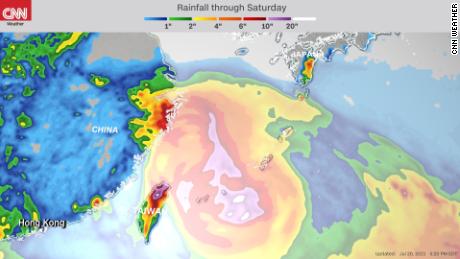
"In-Fa will pass south of Okinawa, closer to Miyakojima, which is built to handle the accompanying rains and wind. The problem may arise as the system moves near Taipei," said CNN meteorologist Tom Sater. Maximum winds near the center of In-fa are forecast to approach 120 mph (195 kph) in the region by Thursday night, when the storm may reach peak intensity.
"The mountain chain in Taiwan could squeeze up to a meter's worth of rain over the region, while Taiwan has been dealing with its worst drought in some 50 years. This amount of rain could lead to catastrophic flash flooding and landslides."
By Friday, In-fa is expected to near Taiwan, possibly bringing significant impacts to the country, especially the northern part of Taiwan, according to the current forecast track.
It is uncertain whether the typhoon will make landfall on the country, but it is expected to at least track close enough for some impacts.
Flash flooding from heavy rain will be a big concern, with totals more than 12 inches (300 millimeters) in the lower elevations and more than 20 inches (500 millimeters) in the mountains of Taiwan later in the week.
Strong winds, which could cause power outages, will be another risk for these areas in eastern Asia. The Joint Typhoon Warning Center is forecasting winds near the center of the storm to peak at 102 mph (165 kph), with higher gusts likely.
In-fa is expected to continue tracking west, reaching eastern China this weekend. The current forecast indicates it will still be at typhoon intensity. Heavy rain will remain a threat from this storm through its duration.
Record rainfall in eastern China ahead of In-fa
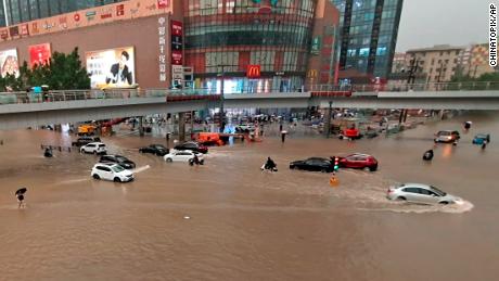
Heavy rain in the Chinese city of Zhengzhou has broken a record, according to the city's meteorological bureau Tuesday.
At least one person was reported dead and two missing amid the floods in China's Gongyi city, in Henan province, according to state news outlet CGTN on Tuesday.
"The hourly precipitation and single-day precipitation this time have broken through the historical record of 60 years since the establishment of Zhengzhou Meteorological Bureau in 1951," the Zhengzhou Meteorological Department said in a video it posted explaining the rainfall.
"The precipitation the city had in the last three days was already tantamount to the total amount of the precipitation the city had last year," the department said.
The average annual rainfall in Zhengzhou is 25/2 inches (640.8 millimeters), according to the bureau. Meanwhile, according their analysis of the recent rainfall, from 4 p.m. to 5 p.m. Tuesday the city saw 7.9 inches (201.9 millimeters) of rainfall. From 8 p.m. Monday to 8 p.m. Tuesday, the city saw 21.8 inches (552.5 millimeters) of rain; and from 8 p.m. Saturday to 8 p.m. Tuesday, the city saw 24.3 inches (617.1 millimeters) of rain.
The moisture associated with this rain can be connected to both Typhoons Cempaka and In-fa, despite being hundreds of miles from this part of China.
Torrential rains have hit central China's Henan province since Friday, affecting more than 144,660 residents, according to China's state news agency Xinhua on Tuesday. More than 10,000 have been relocated to safer places.

The highest level of rainfall was seen in Lushan County's Pingdingshan City with 15.8 inches (400.8 millimeters) of precipitation, Xinhua reports, adding that rainwater has damaged more than 35 square miles (9,000 hectares) of crops, causing losses worth $11.3 million.
"impact" - Google News
July 21, 2021 at 08:38AM
https://ift.tt/3zkGl2K
Typhoon In-fa strengthening while on track to impact Japan, Taiwan and China - CNN
"impact" - Google News
https://ift.tt/2RIFll8
https://ift.tt/3fk35XJ
Bagikan Berita Ini


0 Response to "Typhoon In-fa strengthening while on track to impact Japan, Taiwan and China - CNN"
Post a Comment