
-
The track for Hurricane Laura is seen on Wednesday, Aug. 26, 2020.
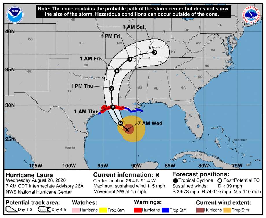
Photo: National Hurricane CenterThe track for Hurricane Laura is seen on Wednesday, Aug. 26, 2020.
The track for Hurricane Laura is seen on Wednesday, Aug. 26, 2020.
The track for Hurricane Laura is seen on Wednesday, Aug. 26, 2020.
Greetings, Houston. Here’s the latest on Hurricane Laura:
Hurricane Laura is expected to make landfall on the Gulf Coast as a major hurricane early Thursday morning.
Noon update:
As of 10 a.m., Houston has a 10 percent chance of experiencing hurricane-force winds and a 60-to-70 percent probability of experiencing tropical storm-force winds of at least 39 mph.
While rainfall totals will remain relatively low (projected no more than 4 inches for Houston), damaging wind is the main threat to the metro area from Hurricane Laura.
The National Hurricane Center warns of "unsurvivable" storm surge from near the Sabine Pass to the middle of the Louisiana coast. While that doesn't spell trouble for the metro area, several of Greater Houston's coastal communities have mandatory or voluntary orders for evacuation.
In Galveston, the McGovern Medical School will close nearly two dozen flood doors on the campus at 1 p.m. Wednesday ahead of the storm. The flood doors were part of $20 million in renovations to the campus after Tropical Storm Allison in 2001, which also included installing an outer berm surrounding the campus and a hydrostatic wall.
9:30 a.m. update:
The track for Hurricane Laura shifted east overnight, meaning Greater Houston all but "dodged a big bullet," according to meteorologists.
But, what does that mean for Houstonians who have been prepping for a worst-case scenario?
While the track is still uncertain, the storm is moving toward the Gulf Coast at nearly 45 mph and is expected to be a "catastrophic" Category 4 hurricane by the time it makes landfall somewhere near the Texas-Louisiana border.
Many meteorologists have been providing updates via Twitter, with Senior Hurricane Specialist Eric Blake calling it a powerful hurricane that's only getting stronger.
I should be sleeping but impossible when this is happening with #Laura. Look at the eye starting to get warm and clear out on this satellite loop. Classic signature of a powerful hurricane getting stronger- just horrible to see it so close to the coast. pic.twitter.com/qivuWfgulL
— Eric Blake 🌀 (@EricBlake12) August 26, 2020
Wow... Hurricane Laura.
A powerful major hurricane bearing down on the Gulf Coast. pic.twitter.com/1IqwXo3gN9
— Dakota Smith (@weatherdak) August 26, 2020
CLOSINGS: These schools have canceled classes due to Hurricane Laura
Houston will still experience rain and possibly heavy winds throughout Wednesday and Thursday, starting with scattered showers and thunderstorms from the southeast starting Wednesday morning. Inland communities will still experience gusty winds starting Wednesday afternoon.
Coastal communities such as Galveston and Boliver will still experience sustained winds upwards of 50 mph this afternoon into the late evening, according to the National Weather Service. The storm surge still remains the biggest impact for the coast, expected to be up to 18 feet in some parts, but it will die down as the night goes on.
The threat of rain diminishes Thursday but picks back up Thursday evening, according to meteorologists.
Much of the Houston area can expect up to 4 inches of rain from Hurricane Laura, a relatively small amount for the intensity of the storm.
Ahead of the hurricane's landfall, Harris County Judge Lina Hidalgo signed a disaster declaration.
NEW: I’ve just signed a disaster declaration for Harris County.
— Lina Hidalgo (@LinaHidalgoTX) August 26, 2020
This will give us additional flexibility to respond and recover to any impacts from Hurricane #Laura pic.twitter.com/ihNIuOzfgx
Check this story for updates as they come in throughout the day.
jay.jordan@chron.com
"impact" - Google News
August 27, 2020 at 12:23AM
https://ift.tt/3lpOSLY
Hurricane Laura: The latest on storm’s impact on Houston - Chron
"impact" - Google News
https://ift.tt/2RIFll8
https://ift.tt/3fk35XJ
Bagikan Berita Ini


0 Response to "Hurricane Laura: The latest on storm’s impact on Houston - Chron"
Post a Comment